Property Record
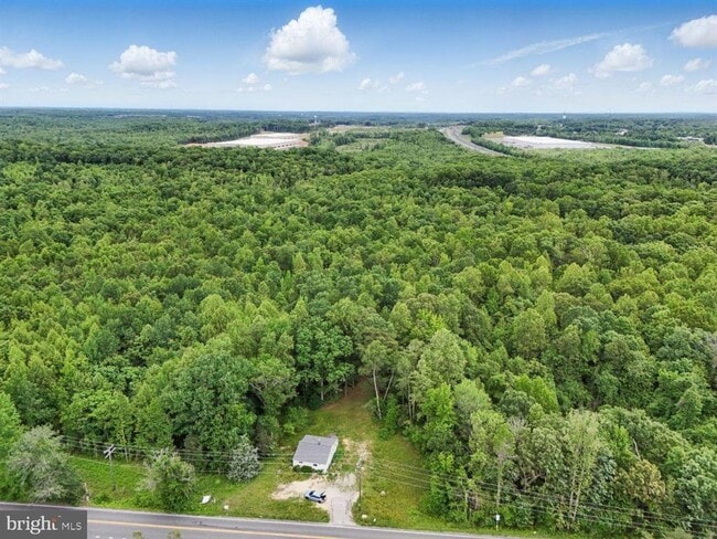
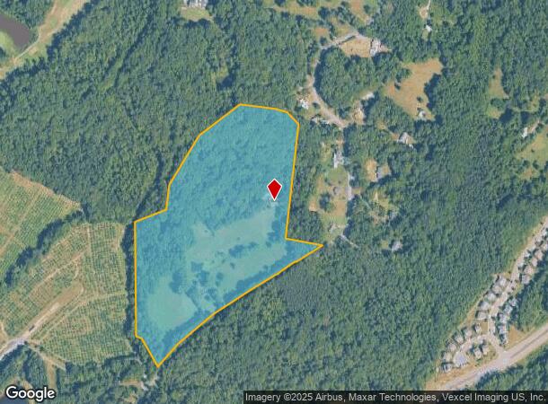
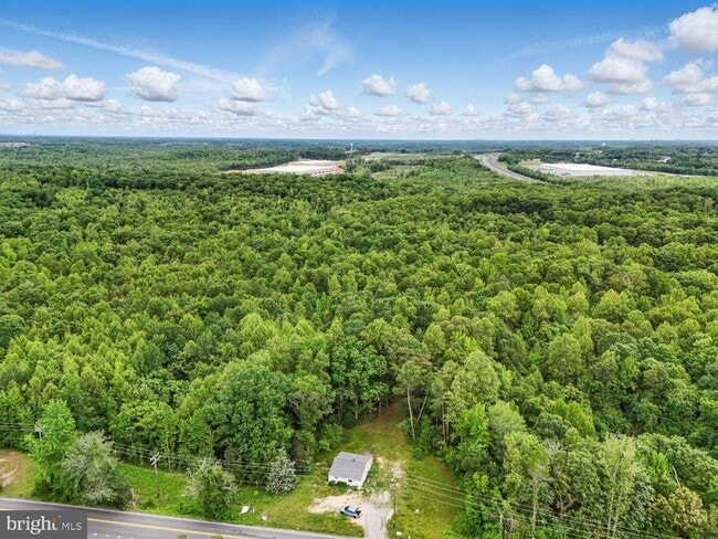
128 Ramoth Church Rd, Stafford, VA 22554

This Property Is For Sale
NEARBY LISTINGS FOR SALE OR LEASE
Property Detail
128 Ramoth Church Rd
28-102
Woodcutting
Agriculturalland
WOODCUTTING 26.6029 AC & 20 RW
AE
Stafford
51179C0137F
Virginia
2024
26.60 AC
2025
Stafford County
010217
Washington, DC
1,798 SF
Washington-Arlington-Alexandria, DC-VA-MD-WV
DEMOGRAPHICS near 128 Ramoth Church Rd
1 Mile
3 Mile
5 Mile
2024 Total Population
3,772
37,258
87,763
2029 Population
4,450
43,611
102,708
Pop Growth 2024-2029
+ 17.97%
+ 17.05%
+ 17.03%
Average Age
38
37
37
2024 Total Households
1,183
11,225
27,244
HH Growth 2024-2029
+ 18.17%
+ 17.23%
+ 17.31%
Median Household Inc
$175,000
$153,053
$125,937
Avg Household Size
3.10
3.30
3.10
2024 Avg HH Vehicles
3.00
3.00
2.00
Median Home Value
$638,205
$453,229
$420,973
Median Year Built
2010
2000
1998
Nearby Places
- Restaurants
- Banks
- Shops
- Fitness
- Groceries
PUBLIC TRANSPORTATION
COMMUTER RAIL
Brooke (Fredericksburg Line - Virginia Railway Express)
DRIVE
WALK
Distance
Brooke (Fredericksburg Line - Virginia Railway Express)
16 min
8.0 mi
Leeland Road (Fredericksburg Line - Virginia Railway Express)
DRIVE
WALK
Distance
Leeland Road (Fredericksburg Line - Virginia Railway Express)
18 min
9.2 mi
Freight Ports
Virginia Port Authority - Richmond
DRIVE
WALK
Distance
Virginia Port Authority - Richmond
91 min
73.5 mi
Nearby Properties
Address
Land Use
TOTAL SIZE
Lot Size
Zoning
Address
Land Use
TOTAL SIZE
Lot Size
Zoning
536,192 SF
72.22 AC
B2
Address
Land Use
TOTAL SIZE
Lot Size
Zoning
175,700 SF
128.43 AC
R3
Address
Land Use
TOTAL SIZE
Lot Size
Zoning
629,378 SF
81.82 AC
M1
Address
Land Use
TOTAL SIZE
Lot Size
Zoning
4,951 SF
36.12 AC
R2
Address
Land Use
TOTAL SIZE
Lot Size
Zoning
122,875 SF
11.61 AC
B2
Address
Land Use
TOTAL SIZE
Lot Size
Zoning
295,187 SF
88.50 AC
A1
Address
Land Use
TOTAL SIZE
Lot Size
Zoning
92,937 SF
540.58 AC
M1
Address
Land Use
TOTAL SIZE
Lot Size
Zoning
244,617 SF
61.73 AC
R3
Address
Land Use
TOTAL SIZE
Lot Size
Zoning
96,370 SF
20.28 AC
PD2
Address
Land Use
TOTAL SIZE
Lot Size
Zoning
496,822 SF
38.33 AC
M1
Address
Land Use
TOTAL SIZE
Lot Size
Zoning
151,015 SF
36.62 AC
A1
Address
Land Use
TOTAL SIZE
Lot Size
Zoning
175,990 SF
50.21 AC
A1
Address
Land Use
TOTAL SIZE
Lot Size
Zoning
77,949 SF
13.59 AC
B2
Address
Land Use
TOTAL SIZE
Lot Size
Zoning
87,891 SF
38.57 AC
PD1
Address
Land Use
TOTAL SIZE
Lot Size
Zoning
168,780 SF
7.23 AC
R3
Address
Land Use
TOTAL SIZE
Lot Size
Zoning
116,700 SF
7.49 AC
B2
Address
Land Use
TOTAL SIZE
Lot Size
Zoning
97,516 SF
26.25 AC
A1
Address
Land Use
TOTAL SIZE
Lot Size
Zoning
146,710 SF
43.68 AC
R1
Address
Land Use
TOTAL SIZE
Lot Size
Zoning
84,974 SF
18.76 AC
R1
Address
Land Use
TOTAL SIZE
Lot Size
Zoning
76,187 SF
23.38 AC
A1
Address
Land Use
TOTAL SIZE
Lot Size
Zoning
82,543 SF
20.89 AC
A1
Address
Land Use
TOTAL SIZE
Lot Size
Zoning
75,936 SF
20 AC
PD1
Address
Land Use
TOTAL SIZE
Lot Size
Zoning
127,035 SF
2.91 AC
B2
Address
Land Use
TOTAL SIZE
Lot Size
Zoning
16,820 SF
37.60 AC
B3
Address
Land Use
TOTAL SIZE
Lot Size
Zoning
57,066 SF
7.59 AC
PD2
Address
Land Use
TOTAL SIZE
Lot Size
Zoning
37,095 SF
12.46 AC
M1
Address
Land Use
TOTAL SIZE
Lot Size
Zoning
106,035 SF
5.35 AC
B2
Address
Land Use
TOTAL SIZE
Lot Size
Zoning
17,638 SF
4.45 AC
A1
Address
Land Use
TOTAL SIZE
Lot Size
Zoning
40,792 SF
15.16 AC
SC
Address
Land Use
TOTAL SIZE
Lot Size
Zoning
42,090 SF
4.44 AC
B2
The World's #1 Commercial Real Estate Marketplace
Connect with us
© 2025 CoStar Group
The information above has been obtained from sources believed reliable. While we do not doubt its accuracy we have not verified it and make no guarantee, warranty or representation about it. It is your responsibility to independently confirm its accuracy and completeness. Any projections, opinions, assumptions, or estimates used are for example only and do not represent the current or future performance of the property. The value of this transaction to you depends on tax and other factors which should be evaluated by your tax, financial, and legal advisors. You and your advisors should conduct a careful, independent investigation of the property to determine to your satisfaction the suitability of the property for your needs.